
Satlink Ocean Service(SOS)
Providing Information Necessary for Fishing Activities

Satlink Ocean Service (SOS)
Satlink Ocean Service (SOS) provides insight into buoys’ context as well as oceanographic information. A buoy with oceanography and echosounder readings below the ocean surface can provide you essential information on the activities by interpreting more logical buoy measurements.
Oceanographic Charts Available in the ELB Manager
・SHEAR
・CHLOROPHYLL
・CURRENTS
・OXYGEN
・SALINITY
・SEA SURFACE HEIGHT
・TEMPERATURE
・THERMOCLINE
Ability to show the oceanographic information available needed with the buoys information.
This way, we can have in a more visual and intuitive way, all the information necessary for the fishing activities in a context that would allow the interpretation of the buoy measurements.
Commentary
Shear: The shear maps show where high currents could cross and indicate that there could be movement of the objects in the water. This map is especially relevant for the purse seiners as an area with high shear can complicate the usage of the fishing net.
Chlorophyll: Chlorophyll maps show us where plant organisms grow from the water surface, a good indicator of where marine ecosystems proliferate. These plant organisms, the phytoplankton, form the basis of the trophic chain, and regions that have a lot of phytoplankton often also have a diverse population of species.
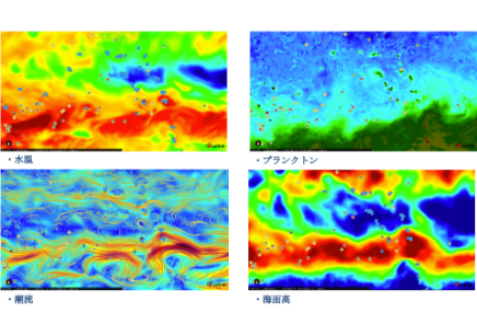
Currents: The currents show us the movements of the oceanic water from one to another. The healthiest and richest fisheries are found in areas where different currents meet and mix as these areas usually have optimal conditions to hold rich species diversity.
Dissolved Oxygen: As Oxygen for humans, the dissolved oxygen in the water is crucial for the marine live and, together with the salinity and the temperature, it defines the biological diversity and the quality of the water. There areas with low dissolved oxygen usually have a lower water quality and hold less variety of species.
Salinity: The changes in salinity give us information on where there are freshwater flows, which often brings nutrients with them. Salinity also affects water density and is key in studying ocean circulation.
Altimetry: The altimetry indicates the height of the sea surface in relation to the average sea level. Altimetry shows upwelling areas, where nutrients are pushed by currents to the surface, and subsidence, where warmer water falls to the seabed.
Temperature: Water temperature is a key factor in defining areas where different species of fish can proliferate, since each species can only survive within certain limits. Temperature differences also direct ocean currents and can give us an indication of nutrient-rich areas.
Thermocline: The depth of the thermocline gives us an indication of the depth to which it reaches the epipelagic zone, where most marine species proliferate. Changes in thermocline depth also affect the behavior and distribution of fish, restricting them to certain layers of depth
Official Website